Treachery
The surf was very small and no shape. Onward!
Wallingat National
Park
I stopped at Sugar Creek Picnic area for the start of a walk
and cycle.
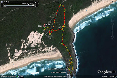
Hotel Creek Loop
The cycle went along the hotel trail then followed Thomas
road and back to the picnic area. The
hotel trail was a challenge with thick leaf litter, branches and low trees. I
had to keep a careful watch on this section and it oozed snake territory
(didn’t see any). The next part was along dirt logging roads with some big pot
holes. I forgot to turn on the GPS until the logging road.
Distance 6.24
km
Coachman Track
After a break, I walked the coachman track. The signs were a
bit poor and the track which meandered through the trees was difficult to
follow due to leaf litter. I went part of the way and returned.
Distance .13km
Time 0:10
Whoota Whoota Lookout
Next, I drove to Whoota Whoota Lookout. The road was steep
and heavily rutted in sections. A hard drive. The view was great though a little
hazy over the hinterland and the coast to the north and the south.
Wallingat River
Continuing, I drove to the Wallingat River camp area. After
lunch, I had a great kayak upriver along the Wallingat River. The end section
broke into sections. I followed both. The water was very clear in these end
sections. I was able to see the rocks, underwater logs and fish. On finishing
as I was drifting near the joining of the two tributaries, I was treated to an
aerial display by two eagles.
Distance 3.97km
Time 1:10
Av speed 3.4kph
Back at the campsite, while having lunch I was further
entertained by a lace monitor. It climbed around and then rested metres away
from me. I was going to stay the night but the weather report predicted rain in
the morning and the road was bad enough dry.
Booti Booti
National Park
Off to the Ruins camping area in Booti Booti National Park.
I checked Boomerang along the way but it was very windblown. The surf at Booti Booti
was also windblown.
Met some teachers/helpers from a Steiner school group. Nice
dedicated people!
Camp: $10

.jpg)
.jpg)


.jpg)

.jpg)

.JPG)